
Jet Stream
Definition
Jet Stream is defined as a flat tubular current of air, quasi-horizontal, whose axis is along a line of maximum speed and which is characterised not only by great speeds but also by strong transverse (horizontal and vertical) gradients of speed (World Meteorological Organisation).
Description
The two major areas of Jet Stream activity in the upper troposphere are the Sub-Tropical Jet Streams near the 30 degree latitudes and the Polar Jet Streams in mid-latitudes. Both are predominantly west-east.
There is also a jet stream of predominantly east-west flow over equatorial land masses, and a belt of strong winds in the stratosphere over the winter pole, the “polar night jet”, at high latitudes and above FL600, or the 50 hPa level.
The Polar Jet Stream is formed as a result of the temperature gradient between the cold polar air mass and the warmer sub-tropical air mass. Since the temperature difference is greatest in the winter, the speed of the Polar Jet Stream is at its highest also in the winter. Its altitude is generally at the 250-300 hPa level.
A Jet Stream can be several thousand miles long, but only a few hundred miles wide and a few thousand feet in depth.
The winds in a Jet Stream are not constant, nor is the direction always west-east. Jet Streams can intensify or die out and therefore the forecasting of Jet Stream location, direction and strength is not as precise as aviators would like when planning long range intercontinental flights.
The Sub-tropical jet Stream is located entirely within the tropical air mass and is not associated with any surface fronts. Its location is less variable than the Polar Jet Streams, and its altitude is at around the 200 hPa level.
The Equatorial Jet Stream, located at approximately FL500, or around the 100 hPa level, flows intermittently east to west across Asia and Africa but does not extend into the Atlantic. It is at its strongest in the months of July and August.
A second jet stream sometimes forms over Africa, underneath the Equatorial Jet Stream. Large cumulonimbus clouds can form around this jet, moving out into the Atlantic ocean, developing further and, if the sea temperatures are warm enough, can trigger the development of a hurricane
To be considered a Jet Stream, the accepted minimum speed limit is 60 knots. The speed of the Jet Stream is typically 100 kts (nautical miles per hour) but can reach 200 kts over North America and Europe in the winter. Speeds of 300 kts are not unheard of, particularly over south-east Asia.
In areas north of the Alps, in the Bavaria regions of Germany, low level jet streams may arise due to the dynamics of the wind structure in that area, especially with winds from the east.
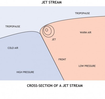
Cross Section of a Polar Jet Stream
The location of the Polar and Sub-Tropical Jet Streams is influenced by climatic variations such as El Niño and La Niña.
Effects
- Ground Speed. Aircraft flying west-east will try to exploit the Jet Stream to increase ground speed and, similarly, aircraft flying East-West will plan to avoid the Jet Stream.
- An unexpected encounter with a Jet Stream while heading West, or failure to gain the expected benefit of flying with the Jet Stream on a west-east flight, will reduce an aircraft’s planned fuel reserves overhead its destination and, in extreme cases, cause it to declare a fuel emergency or divert to an enroute airfield in order to refuel.
- Clear Air Turbulence. Aircraft flying close to a Jet Stream may encounter Clear Air Turbulence (CAT)(CAT) caused by Low Level Wind Shear. The CAT is strongest on the cold/low pressure side of the jet (the north side in the northern hemisphere) next to and just underneath the axis of the Jet Stream.
- Not all jet streams are turbulent but aircraft exploiting the tailwinds afforded by a Jet Stream often experience light to moderate turbulence for much of the flight.
- This turbulence can sometimes be severe and has on at least one occasion led to the death of a passenger (see Further Reading).
- Jet Streams passing over mountains usually produce waves of considerable amplitude and this increases the risk of turbulence.
- Indicated Airspeed. An aircraft descending from calmer winds to stronger winds will encounter an increase in indicated airspeed. Care should be taken when flying at maximum speed not to over speed the aircraft. Likewise, an aircraft flying into a rapidly increasing tail wind jet stream can see a reduction in indicated airspeed and if not managed end up in an airspeed low scenario.
Defenses
- Flight Planning. SIGMETcharts display the forecast location and strength of Jet Streams, the level of the tropopause and areas of Clear Air Turbulence (CAT).
- Significant weather charts also show Jet Streams, Fronts, and areas of CB, icing and turbulence forecasted.
- Airmanship. A rapid change in Outside Air Temperature(OAT) indicates passage from one air mass to another, and if the aircraft is close to the Tropopause this can indicate the likely presence of a Jet Stream.
Scenarios
- An aircraft encounters unexpected, strong headwinds. The captain descends in an attempt to get out of the Jet Stream; the ground speed increases but the fuel burn is higher than planned at the lower flight level. The aircraft does not have sufficient fuel to make its destination with required minimum fuel reserves. The captain therefore elects to land and refuel at an en route airfield.
Contributory Factors
- Rapidly moving weather systems making forecasting of location and strength of Jet Streams less accurate.
- Delayed departure such that the flight/fuel plan are optimised for wind patterns which have since changed.
Solutions
- When flying in an area of forecast CAT, the crew should err on the safe side and keep the passenger seat belt sign illuminated. This may of course disrupt the cabin service and cause distress to passengers so the seat belt sign should not be left on unnecessarily.
- If encountering unexpectedly strong headwinds:
- Record ground speed and fuel burn and try flying 2,000 ft and 4,000 ft lower. Compare the ground speed and fuel burn at those levels and fly at the level which gives the best specific ground range (the lowest kg/nm figure).
- Seek information from aircraft ahead and to the north and south of your planned track to find out what winds they are experiencing and consider adjusting your route to avoid the high winds.
- When you are eventually free of the strong headwinds, consider flying long range cruise/fuel economy speed and profile to conserve fuel.
- Start contingency planning for an intermediate fuel stop.
- Consider the consequences of the longer flight time e.g. destination weather forecast, opening times, crew duty times etc.
Write a Comment