
Weather Observations at Aerodromes
Description
This article describes how the aerodrome weather observation data is obtained and disseminated to the users concerned. It also outlines the basic procedures for establishing and performing weather observations as well as the requirements for the observing equipment and the qualification of the met observers. Slight country-to-country variations are possible.
Uses
Weather observation data is mostly used for the following purposes:
- METAR reports are provided at regular intervals (usually 30 minutes) and provide essential weather information about an aerodrome. Data should be representative for the whole aerodrome operating area.
- Special reports (SPECI) are be produced as dictated by the weather conditions (when there is significant deterioration or improvement in airport weather conditions, such as significant changes of surface winds, visibility, cloud base height and occurrence of severe weather). The criteria for the production of a special report and information dissemination are laid down in relevant local documents.
- The format of the SPECI report is similar to that of the METAR and the elements used have the same meaning. The identifier METAR or SPECI at the beginning of the weather report differentiates them.
- TAF (terminal area forecast)- the aerodrome forecast consists of a concise statement of the expected meteorological conditions at an aerodrome for a specified period.
- Automatic Terminal Information Service (ATIS)- is a continuous broadcast of recorded non-ATC aeronautical information.
- VOLMET – a worldwide network of radio stations that broadcast TAF, SIGMET and METAR reports.
- Weather reports to ATS. Weather reports to Air Traffic Services are usually issued half-hourly and are used by the ATS unit to provide weather information to operators, aerodrome users and pilots at or in the vicinity of the aerodrome. Whilst these reports are very similar to the METAR, there are slight differences in content and coding.
General Procedures
This section outlines the general requirements for the provision of meteorological data and reports. Note that these may vary from country to country.
- At licensed aerodromes, the aerodrome licensee is responsible for arranging the provision of aerodrome weather observations and other meteorological information to users. This function may be performed by staff directly employed or contracted by the aerodrome licensee.
- The compilation of aerodrome weather reports are usually defined as a responsibility of the Aerodrome Meteorological Observing Service Provider (which, in most cases, is an ANSP).
- A system should be in place that assures users that the quality of meteorological information supplied complies with the relevant regulation requirements.
- Official Meteorological Reports, if in the form of a meteorological aerodrome report (METAR), may be disseminated beyond an aerodrome to pilots and other meteorological service providers using processes that adhere to ICAO Standards. The observer should be accredited and competent to produce these observations and the instrumentation used should comply with the relevant regulation requirements.
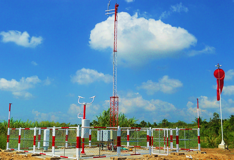
- The Met Observers at an aerodrome should be located, as far as possible, in a position that enables them to supply observations which are representative of the aerodrome and its vicinity.
- The observer should continuously monitor the weather. Observations should be updated, as necessary, in a timely manner.
- A weather report that has not been validated by an accredited observer may be distributed locally and to the meteorological forecast office. Such a report needs to be clearly identified as unofficial and prefixed as such when being passed to aircraft or other agency.
- The observer is expected to provide a full non-routine observation at the time of an aircraft accident on or in the vicinity of the aerodrome. This is done to ensure that complete details of the weather at the time of the incident will be available to an official inquiry.
- Automated sensors used to measure certain meteorological elements (typically visibility, present weather and cloud) should be considered to be an aid to an observer rather than a direct source of information for the official weather report. Also, procedures should ensure that any observation generated by a semi-automatic observing system is not disseminated unless it has been checked and qualified by an accredited observer.
- Procedures for automatic weather report generation and dissemination should be in accordance with local regulations.
Accreditation of Observers
This section outlines the basic requirements for weather observer accreditation. Note that these may vary from country to country.
- The Aerodrome Meteorological Observing Service Provider is responsible for ensuring the competence of each aerodrome meteorological observer employed at the aerodrome.
- The Aerodrome Meteorological Observing Service Provider should ensure that observing staff are sufficiently familiar with all meteorological phenomena that can reasonably be expected to occur at the aerodrome.
- The requirements for a Meteorological Observer’s Certificate may vary from country to country, but usually each aerodrome meteorological observer must successfully complete a recognised course of training on the preparation of aerodrome weather reports and must demonstrate basic competence in compiling such reports.
- The certification process usually comprises two parts:
- The theory part provides the necessary background information on all elements of aerodrome meteorological observing; this is examined to ensure that the concepts have been fully understood.
- The practical part puts the aerodrome meteorological observer trainee under the supervision of an experienced observer so that observing techniques are practiced and the performance assessed.
- When semi-automated observing systems are used, measurements of horizontal visibility, present weather and cloud need to be validated by an accredited observer before being issued as a METAR. In such cases reduced training may be provided, concentrating on observing these elements. A restricted met observer’s certificate is then awarded to clearly describe the holder’s competence.
- A restricted met observer’s certificate may only be transferred to another aerodrome where a semi-automated observing system is in operation.
- The Aerodrome Meteorological Observing Service Provider should ensure that all accredited aerodrome met observers maintain their observing competence. Provisions regarding the required conditions for certificate maintenance (e.g. minimum number of observations made over a period of time) are laid down in relevant documents.
- Following changes to observing practices or aeronautical codes, the Aerodrome Meteorological Observing Service Provider should ensure that all staff are made aware of the changes and additional training is arranged as necessary.
- Refresher training is required for the met observers nominated to carry out the competency checking of their colleagues. Met observers who have not observed for a specified period of time are subject to refresher training too.
Surface Wind
- Surface wind information for the METAR report should be taken from an anemometer located on the aerodrome. The anemometer should be sited in a suitable location to provide a representative measurement for the aerodrome.
- The direction from which the surface wind is blowing is given in degrees from true North and the speed is usually given in knots.
- The direction and speed reported are the averages taken over a ten minute period immediately preceding the time of the observation.
- The maximum wind (gust) is reported only if it exceeds the mean speed by 10 knots or more.
- Variations in wind direction are reported only when the total variation in direction is 60 degrees or more or but less than 180 degrees and the average wind speed is greater than 3 knots.
- The mean wind direction is not included when the wind is reported as “variable”:
- when wind speed is 3 knots or less;
- when the total variation in direction is 180 degrees or more;
- when it is not possible to report a mean direction e.g. when a thunderstorm passes over the aerodrome.
- When the wind speed is less than 1 knot, this should be reported as calm.
- It is recommended that averages of wind speed and variations in the wind direction and speed are generated by automatic equipment.
- The direction mean and variations are rounded to the nearest 10 degrees in the METAR. Values ending with 5 are rounded down.
- The mean speed and maximum speed are rounded to the nearest knot in the METAR and reported between 01 and 99 knots. Speeds exceeding 99 knots are coded as “P99”.
- The surface wind information provided should be representative of the conditions along the runway. Since, in practice, the surface wind cannot be measured directly on the runway, surface wind observations for take-off and landing should be sited to give the best practicable indication of conditions along the runway.
- In reports to aircraft for take-off and landing, direction is to be expressed in degrees Magnetic, and the reading is averaged over the previous 2 minutes; in addition, the extremes in direction and speed (gust and lull) during the past 10 minutes should be provided. The instantaneous surface wind should be available to give to pilots on request.
- Maximum (gust) and minimum (lull) wind speeds should be provided when the difference is 10 knots or more from the 2-minute mean wind speed.
- Variations in wind direction should be reported when the total variation in direction over the previous ten-minute period is 60 degrees or more. Variations are reported in clockwise order (e.g. 290V090 or 170V250).
- Criteria for reporting wind as “variable” are the same as in METAR.
CAVOK
The visibility, RVR, weather and cloud groups are replaced by CAVOK (Cloud And Visibility OK) when the following conditions exist simultaneously:
- Prevailing visibility is 10 km or more.
- No minimum visibility is reported.
- No cloud below 5000 ft or below the highest Minimum Sector Altitude, whichever is the greater.
- No towering cumulus or cumulonimbus
- No significant weather phenomena at or in the vicinity of the aerodrome.
Visibility
- In the METAR, the visibility reported is the prevailing visibility and, under certain circumstances, the minimum visibility. In order to determine the prevailing visibility and any requirement to report the minimum visibility, the variation of visibility in all directions around the aerodrome should be considered.
- Prevailing visibility is defined as “the greatest visibility value that is reached within at least half the horizon circle or within at least half of the surface of the aerodrome. These areas could comprise contiguous or non-contiguous sectors.”
- The visibility reported in the METAR should be assessed at a height of about 1.5 m above the ground at the observing site.
- If the visibility in one direction which is not the prevailing visibility, is less than 1500 m or less than 50% of the prevailing visibility, the lowest visibility observed should be reported after the prevailing visibility and its general direction in relation to the aerodrome indicated by reference to one of the eight points of the compass. If the lowest visibility is observed in more than one direction, then the most operationally significant direction should be reported.
- Visibility is recorded in metres rounded down to:
- the nearest 50 m when the visibility is less than 800 m;
- the nearest 100 m when the visibility is 800 m or more but less than 5000 m;
- the nearest 1000 m when the visibility is 5000 m or more but less than 10 km.
- Visibility of more than 10 km is reported as 10 km. Minimum visibility is not reported if above 10 km.
Assessment of Prevailing Visibility
- The horizon circle is divided into as many sectors of equal visibility as needed to measure the differing visibilities.
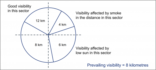
Example of prevailing visibility measurement
- Prevailing visibility is the greatest visibility value which is reached within at least half the horizon circle or within at least half of the surface of the aerodrome; in the above example, the visibility value which is reached within at least half the horizon circle is 8 kilometers (the area covered by the 8km and 12km visibility sectors).
- The lowest visibility is also reported in the METAR when it is less than 1500 metres (providing it is not the prevailing visibility) or less than 50% of the prevailing visibility, along with its general direction. In the above case, the lowest visibility (4 kilometers) is not reported, as it is not less than 50% of the prevailing visibility.
RVR
- Runway Visual Range (RVR) is a measure of the horizontal visibility along the runway. RVR assessments are made either by human observation (HORVR) or an Instrument RVR (IRVR)
- HORVR is usually only reported for the touchdown zone. IRVR systems may have sensors located at the touchdown zone, mid-point and stop end of each runway. For METAR purposes, only the touchdown zone measurement is given.
- Where there is more than one runway available for landing, the touchdown zone RVR should be included for all of them (up to four).
- For METAR reports the RVR should be based on the maximum light intensity available on the runway.
- The RVR group is reported in the METAR only when either the minimum visibility or the runway visual range is observed to be less than 1500 m.
- RVR is reported in metres, rounded down to:
- the nearest 25 m for RVR below 400 m;
- the nearest 50 m for RVR between 400 m and 800 m;
- the nearest 100 m for RVR above 800 m.
- The minimum reportable RVR is 50 m and the maximum is 2000 m.
- The RVR reported in METARs is the average taken over a ten minute period immediately preceding the time of the observation. In ATS, this period is 1 minute.
- The report to ATS includes the RVR reading for the runway in use at the time of the observation. This data may be displayed at the observer’s workplace or may be provided by the ATS unit.
Present Weather
- Entries of present weather only relate to weather occurring at the time of observation on or over the aerodrome. In the case of reporting phenomena in the vicinity of the aerodrome, it should be within 8 km of the Aerodrome Reference Point. Visual reference points, information from radar, pilot reports and automatic sensors may be used to assist in this determination.
- Present weather groups consist of one or more pairs of letter abbreviations. A group is constructed by specifying:
- intensity (light, moderate, heavy, well developed);
- descriptor (e.g. shallow, patches, partial, low drifting, blowing, freezing, thunderstorm);
- phenomenon (e.g. rain, snow, fog, mist, hail, haze, volcanic ash, etc.).
- Up to three groups may be inserted to report simultaneously occurring independent phenomena. Where two different types of weather are observed, they should be reported in two separate groups. However, different types of precipitation occurring at the time of the observation should be reported as one single group with the dominant type of precipitation reported first.
Clouds
- Cloud coding includes:
- amount (FEW, SCT, BKN or OVC);
- height in 100s of feet;
- cloud type (Cb and TCu only).
Note: If no clouds are observed, “NSC” (no significant cloud) is used in METAR. If automated reporting systems are used, “NCD” (no cloud discernible) is used instead of “NSC”.
- Normally up to three cloud layers may be reported (although in certain circumstances more can be reported):
- the lowest layer, whatever the amount;
- the next layer above of amount 3 oktas or more (SCT, BKN or OVC);
- the next layer above of amount 5 oktas or more (BKN or OVC);
- any towering cumulus or cumulonimbus cloud omitted by the other rules, whilst retaining base height order from lowest to highest.
- If there is no cloud below 5000 ft or below the highest minimum sector altitude (whichever is greater) and there is no towering cumulus or cumulonimbus, ‘NSC’ is reported.
- The height of the cloud base is rounded down to the nearest hundred ft up to 10000 ft and to 1000 ft thereafter.
- In reports to Air Traffic Services, cloud layers above 5000 ft should be omitted, but CB and TCU should always be reported whatever the height of the cloud base.
Temperature
- Two temperatures are given in the METAR; the outside air temperature and the dew point. The dew point is not measured directly from a thermometer; however it can be calculated from the dry bulb and wet bulb temperatures or the relative humidity. When the wet-bulb is frozen, the ice-bulb temperature is used to compute dew point.
- The dry bulb and dew point temperatures are reported to the nearest whole degree Celsius (°C). A value of 0.5 degrees is rounded to the warmer temperature. In METAR, a two-digit figure for each temperature is given, preceded by ‘M’ if a temperature is negative.
QNH
- The QNH is the atmospheric pressure corrected to mean sea level (based on International Standard Atmosphere conditions throughout the height difference) and is reported in the METAR rounded down to the nearest whole hectopascal.
- Some aerodromes report the QNH pressure in the METAR in inches of mercury.
- In reports to Air Traffic Services, aerodrome QNH, QFE and, if appropriate, threshold QFE(s) should be reported.
- At aerodromes that have an instrument runway with a threshold elevation 7ft or more below the aerodrome elevation, a threshold QFE may need to be provided during periods that the runway is in use.
Runway Surface Conditions
- If a runway inspection is not possible, it is preferable to report changes by general assessment rather than let a clearly unrepresentative message be repeated, e.g.:
- if snow is judged to be turning to slush;
- if it is apparent that snow depth has increased/decreased.
- Appropriate local arrangements should be in place to ensure that a runway state message is available to the observer in good time for insertion into the next METAR.
- The depth of the deposit reported should be the average of the readings for the usable length of the runway.
Supplementary Information to ATS
- In reports to Air Traffic Services, extra data of use to pilots may be reported in the form of ‘supplementary information’. This may include but is not limited to:
- Marked variations in visibility.
- Aircraft reports of severe turbulence and icing, but only after notification to the meteorological forecast office.
- Fog in the vicinity, with a direction to indicate the location, and patches or banks of fog with their location.
- Distance and direction of showers in the vicinity.
- Aircraft reports of wind shear.
- Significant meteorological conditions, particularly those in the approach and climb-out areas. These may include cumulonimbus clouds, thunderstorms, hail, severe squall lines, freezing precipitation, severe mountain waves and blowing snow.
- Where directions of phenomena are given, one of the eight main compass points should be used.
- Supplementary information should not be used for relaying forecasts, e.g. ‘fog to the west’ may be used but ‘fog thickening’ may not.
Write a Comment