
CUMULONIMBUS CLOUD
CUMULONIMBUS CLOUD: Cumulonimbus is a heavy and dense cloud of considerable vertical extent in the form of a mountain or huge tower, often associated with heavy precipitation, lightning and thunder. The mature Cumulonimbus cloud has a distinctive flat, anvil shaped top.
Description
The Cumulonimbus cloud (Cb) forms when three conditions are met:
- There must be a deep layer of unstable air.
- The air must be warm and moist.
- A trigger mechanism must cause the warm moist air to rise:
- Heating of the layer of air close to the surface.
- Rising ground forcing the air upwards (orographic uplift).
- A front forcing the air upwards.

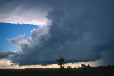
Cumulonimbus cloud in central Oklahoma. The updraft is the large cloud mass at the center of the photo. The anvil is the flat layer at the top. The downdraft is the rainy area to the right.
Types of Cumulonimbus
- Convection. Caused by heating of the layer of air close to the surface. This type of Cb commonly forms in the late afternoon after the peak diurnal heating. Thunderstorms of this type are a daily occurrence in many areas of the tropics. The storms are usually single Cb cells rather than clusters of cells and so can generally be avoided by flying around them.
- Orographic Uplift. Caused by rising ground forcing the air upwards (Orographic Lift). These storms form when a general flow of moist unstable air passes over higher terrain, such as a ridge line or mountain range. Such storms often form in a line along the ground feature and are therefore more challenging to avoid than single cells.
- Mass Ascent. Caused when a weather front forces the air upwards. As with orographic lift, the Cb cells form in a line along the front, frequently embedded within wider frontal cloud, therefore presenting a challenge to aircraft trying to navigate through the front.
Effects
- Turbulence. Vertical movement within a Cb can be as much as 50kt. The interaction between strong updrafts and strong downdrafts causes wind shear and severe turbulence within the cloud.
- Strong surface winds, variable in direction and strength, are common at surface level in the vicinity of the Cb. These can be particularly hazardous to aircraft on take-off or landing.
- In-Flight Icing. Moderate to Severe icing can be expected, especially in the higher levels of the cloud.
- Electrical disturbance. Aircraft flying in the vicinity of Cb clouds may experience electrical disturbances effecting communications and navigation systems.
- The electrical phenomenon known as St Elmo’s fire, while not a threat to safe flight, is an indication of nearby Cb activity. Aircraft in the vicinity of a Cb are at risk of being hit by Lightning.
- Precipitation. Hail can cause significant structural damage to an aircraft. Other precipitation, such as snow, sleet, or rain, can contaminate airfield and runway surfaces creating a hazard to aircraft attempting to take-off or land.
- Extreme weather. Severe downdrafts, microbursts and funnel clouds such as Tornados are also features of cumulonimbus clouds.
Defenses
Flight into a Cb is highly dangerous. The only sensible defense against the hazards associated with a Cb is therefore to avoid flying into one in the first place.
- Planning. Predicting an individual Cb cell is difficult but it is possible to predict the conditions which will trigger formation of a Cb
- Forecasters are therefore able to advise flight crews and controllers of the likely timing, location, direction of movement, and height of cells and whether or not they may be embedded.
- Airport authorities can plan aircraft movements to take into account the disruption to operations caused by storms, and approach controllers can consider how they will manage en-route, departing, and arriving traffic when storms are in the vicinity.
- Flight crews can alter their routings to avoid forecast Cb activity or decide to carry extra contingency fuel in case they have to re-route in flight to avoid the storms or burn additional fuel because of the potential use of aircraft de/anti icing systems.
- Awareness. Awareness of the conditions which lead to the formation of a Cb, recognition of a developing and mature Cb, and awareness of the signs which indicate the proximity of a Cb will help controllers and flight crews to plan operations to avoid the associated hazards.
- Weather Radar. In addition to visual recognition, Weather Radar is a particularly valuable aid to avoiding Cb clouds.
- Airborne weather radar enables the flight crew to identify the areas of the storm cloud which hold the largest water droplets, which indicate the areas with strongest updrafts.
- The area of the cloud with the most severe turbulence is where the updrafts adjoin the downdrafts; therefore the pilot must avoid flying through the edge of the areas of cloud with the largest water droplets.
- It should be remembered that a large cloud will absorb a great deal of the radar pulse which may therefore not penetrate all the way through the storm.
- This can give a false impression that there are no Cb cells beyond the cell immediately ahead of the aircraft.
- In flight avoidance. In certain circumstances, navigating through a line of Cb cells may be the only option open to a pilot, either because his destination is beyond the line of cells or because he is unable to climb over them.
- In such circumstances, the aircraft may have to diverge from track by many, perhaps hundreds of miles, in order to find a gap in the wall of Cb clouds.
- The aircraft captain will need to judge the least hazardous track to follow through the line of cells, something which will absorb the whole crew’s attention. The Weather Radar is invaluable in this situation.
If the Cb cell is situated over the destination aerodrome, then the pilot would be well advised to hold off or divert rather than attempt a landing.
Write a Comment